
Inaugural Forecast with Colder Air on the Horizon
Welcome!!
Though there is not a whole lot of snow on the ground or in the short-term forecast at the moment, Danny Hogan and I are so excited to launch our weather website. We'll be posting weekly forecasts on Thursdays (and potentially more frequently if something particularly exciting is happening). We'll also be building out the Model Tools pages to be a one-stop-shop for models and observations for your favorite backcountry zones.
Forecast Discussion
Through fits and starts, this ski season has struggled to find its footing. Snow coverage remains exceptionally poor. Nearly all of Western Washington Snow Telemetry (SNOTEL) sites are below 50% of median to date. The few exceptions are the highest elevation sites abopve ~5500' that have seen some snow out of these recent storms.
For most of Friday through Saturday, Western Washington will be sitting on the southern edge of weak (AR1) atmospheric river while it makes landfall on Vancouver Island. Expect mild temperatures and some high clouds with some precipitation across the far North Cascades. Any precipitation that does make its way south will bring with it high freezing levels (>6000ft), limiting any snow to the highest terrain.
This all begins to change early Sunday morning as the subtropical moisture finally slides south, opening the door for more widespread precipitation across the WA Cascades. It gets even better though as a shortwave trough moves through late on Sunday, bringing with it glorious cold air. There is strong ensemble agreement for freezing levels to drop around 3-6pm Sunday afternoon, reaching below 3500ft by Monday morning. Snow accumulation will be limited because of the timing of the cold air and the low precipitation totals (relative to Washington in Novermber).
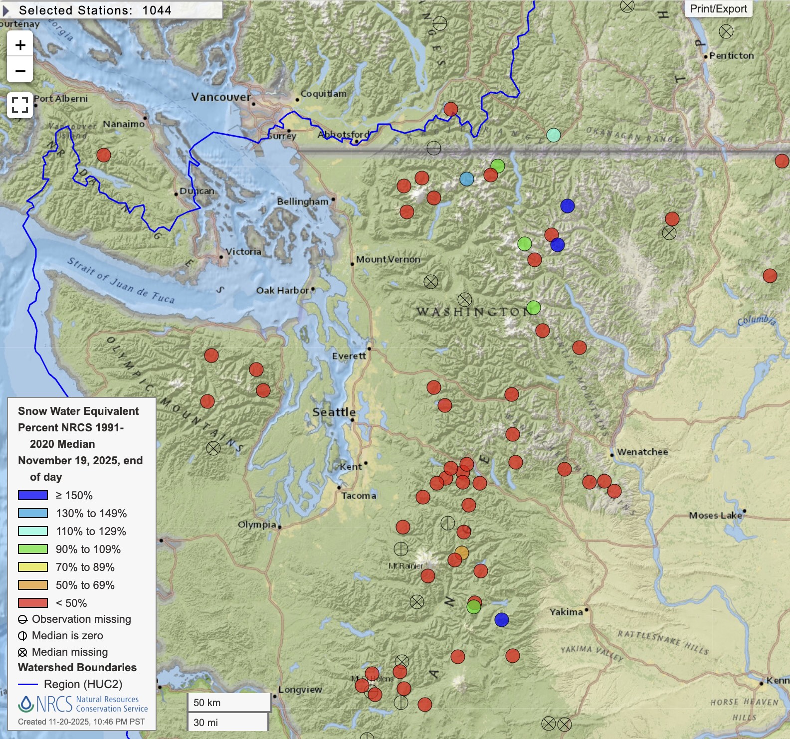
🎯 Weekend Summary
Best Bets: Washington Pass
New Snow Expected: 6-10" through Monday AM
Conditions: Sharky! Limited snow cover accross the board
❄️ Precipitation & Snowfall
Total Weekend Accumulation (through 4am Monday 24 Nov):
- Mt. Baker: 7-12"
- Stevens Pass: 3-7"
- Crystal Mountain: 3-7"
- Snoqualmie: T-3"
- Washington Pass: 6-10"
The Baker Backcountry will likely be the snow total winner but with a current limited to non-existent base, skiing in the Heather Meadows area will be thin and challenging at best.
🧊 Freezing Level
Current Trend: slight warming trend before sharp drop Monday
- Saturday Morning: 6500-7500 feet
- Saturday Afternoon-Evening: 6000-7000 feet
- Sunday: 5500-6500 feet
- Monday Morning: 3000-4000 feet
Impact: Most of this systems precipitation will fall as rain over most of the region, with limited snow accumulation as colder air moves through Sunday night into Monday.
🔮 Extended Outlook (Next 7-10 Days)
Week of 24-30 November 2025
Monday-Tuesday: Precip tapers off Monday night into Tuesday morning across the mountains providing a brief window to dry out ahead of the next system. Some of the coldest air of the season so far, freezing levels <3500ft.
Wednesday-Thursday: Both the ECMWF (European) and GFS (US) models bring precipitation with a sub-tropical moisture component, they differ greatly. The ECMWF solution is shorter-lived and less wet.
Friday-Weekend: Too much uncertainty to make a reasonable forcast.
Snow Pattern Summary
Very high uncertainty past the 5-day mark, we'll have to wait and see if the ensembles can converge on one of the colder solutions.
Longer Range: If we want to play the 200hr+ fantasy land game, the GFS model currently shows a monster trough, cutoff from mean flow at both the upper and lower levels of the atmosphere, with 700mb (~10,000') temperatures below -20C. This would bring snow to Seattle if it validates but it is highly unlikely (<10% chance).
🎿 Our Recommendations
Best Choice This Weekend: Washington Pass
We will likely find ourselves in a pickle once again this weekend. Perhaps the only place with enough snow to ski without an inordinate amount of effort is Washinton Pass. However, if it receives enough snow to provide even half-decent skiing, WA20 and the pass will likely close again. Oh well... 🤷♂️
Runner-Up: Alaska (I'm only half-joking)
The Tincan SNOTEL site near Alyeska currently has 55" of settled depth so...
Other Good Options
Knitting, football, and waxing your skis!