
Thankful for Family, Friends, and Fresh Tracks 🦃
Welcome to The Dendritic Growth Zone!
What is the Dendritic Growth Zone?
The Dendritic Growth Zone, or DGZ for short, is the atmospheric lay every snow lover's dreams. It's where the temperature and humidity are just right to form large, low-density snowflakes that produce the light, fluffy powder we all crave. Snowflakes that form in the DGZ tend to be the most dendritic, meaning they have those classic, intricate branching patterns.The diagram below (called a Nakaya diagram) illustrates the conditions that different types of snowflakes form in. We decided to name our blog The Dendritic Growth Zone because it captures the essence of what we love about forecasting in the PNW. This is a goldilocks region, sometimes it's good, sometimes it's bad, but when it's just right, the snow can be truly unbeatable!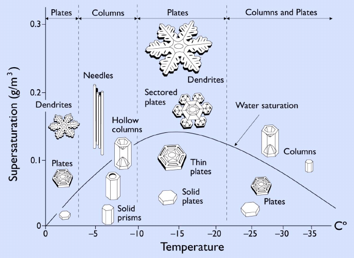
Forecast Discussion
Happy Thanksgiving weekend, everyone! We hope you had a wonderful holiday filled with good food, great company, and maybe even some time on the slopes. A productive week of winter weather brought 6–12 inches of settled snow across all forecast areas, aided by cold easterly flow as last week’s low pressure system moved inland. Today, a low spinning off the Washington–Oregon coast is pushing a warm front across the region, raising snow levels to around 5,000–6,000 ft and keeping precipitation mostly as rain outside the higher terrain. As the cold front follows tonight into Friday, steady precipitation continues. Most areas can expect 5–12 inches, with higher elevations seeing more. However, temperatures at the passes remain the major forecast challenge. Pass-level air is still below freezing, and the persistent “ice box” setup could hold long enough to support freezing rain before colder air fully scours out. Nevertheless, Stevens Pass currently stands out as the storm’s likely winner, with 5–15 inches possible. Heading into the weekend, a robust ridge builds offshore, shifting flow northerly and ushering in cooler air. A weak shortwave embedded on the ridge’s leading edge arrives Saturday, bringing round of light snow with generally good model agreement of a few inches possible. One caveat is that this shortwave is dropping in from British Columbia rather than tapping Pacific moisture, which could leave totals on the lower end. Behind it, colder air settles in for Saturday and Sunday, especially east of the crest. Meanwhile, a significant Arctic airmass is plunging down the eastern Rockies, missing the Pacific Northwest but setting the stage for frigid conditions in Montana, Idaho, and Wyoming.
🚧👷Site updates and features coming soon👷🚧!
Our dreams of snow are finally coming together as our team is hard at work improving our site. We made some substantial changes this week! Most notably, we purchased the domain www.cascademountainweather.com, which is now searchable on Google. We also improved our mobile experience, so you can check the forecast on the go! Lastly, we added a few additional forecast locations and integrated meteorological station observations from each site. These update automatically every hour. However, there is still much to do! We will continue improving the user experience with an emphasis on mobile functionality. We are also working on adding new forecast graphics and interactive tools to help you plan your adventures. Finally, we plan to offer a forecast evaluation page to track how different models perform over the winter! Thanks again for visiting!
🎯 Weekend Summary
Best Bets: Stevens Pass
New Snow Expected: 5-15" through Saturday
Conditions: Still low snow conditions so higher elevations are best, but good visibility with high pressure after new snowfall should provide some nice views!
❄️ Precipitation & Snowfall
Weekend Snow Accumulation (through 4am Monday 1 Dec):
- Mt. Baker: 5-10"
- Stevens Pass: 3-12"
- Snoqualmie: 2-5"
- Blewett Pass: 3-6"
- Paradise: 2-12"
- White Pass: 3-8"
🧊 Freezing Level
Current Trend: Dropping before rising through the weekend
- Saturday Morning: 2000-3000 feet
- Saturday Afternoon-Evening: 4000-6000 feet
- Sunday: 2000-6000 feet
Impact: Possible freezing rain at lower elevation passes could make for difficult travel conditions Friday. Big temperature difference between west and east sides of passes.
🔮 Extended Outlook (Next 7-10 Days)
Week of December 1-6
Monday-Tuesday: Dry conditions with high pressure in place.
Wednesday-Thursday: Weak shortwave coming down from the north.
Friday-Weekend: Big uncertainty ranging from strong storms to continued ridging.
Snow Pattern Summary
After this Thanksgiving and Black Friday storm setup, things dry out without big storms on the near-term horizon
🎿 Our Recommendations
Best Choice This Weekend: Stevens Pass
Highly variable but gained a good amount of snow earlier in the week and projected to be the storm winner.
Runner-Up: Mt. Baker Backcountry
Being further north, Baker could get a better dose of the upcoming shortwave.
Rolling the Dice: Paradise
Paradise has a BIG ensemble spread but this area could benefit with its higher elevation