
In this week's edition of the Dendritic Growth Zone Forecast Blog what's that?
Gulf of Alaska troughing continues to pummel us, but will snow come along for the ride?
🎯 The Short Version
Unseasonably mild conditions will wrap up Friday as the warm front finally moves across Washington with precipitation accumulating from south to north on Friday. But don't think you'll dry out too fast: another (cooler) frontal system arrives Saturday evening, making for a rainy (and potentially snowy??) Sunday.
📑 Contents
1. Past Week Recap
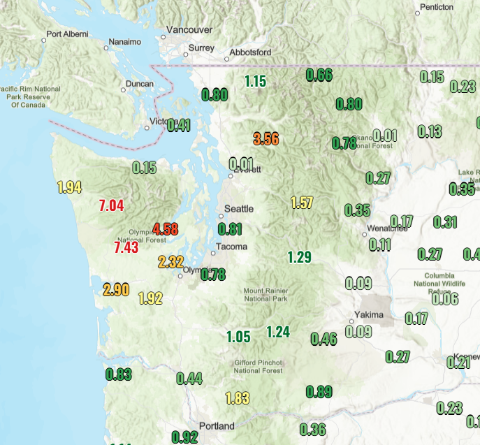
Last week brought a parade of atmospheric rivers to the Pacific Northwest. Precipitation totals were concentrated on the southwestern side of the Olympics (Skokomish River has a flood watch), but the region surrounding Glacier Peak also received a greater share due to some concentrated intense precipitation last Sunday. Even with these storms, mountain precipitation gauges are still sitting around 60% of normal since October 1 because of our very dry October. Unfortunately, temperatures did not cooperate to bring snowfall, too. The last seven days have been around 4 to 7 degrees above normal in the mountains.
- How last week's forecast did: Our precipitation and snow forecast fell in line with the models we compare to (HRRR, RRFS, HRDPS, NBM), though we had slightly lower bias. Relative to the other models, our forecast performed best at Mt. Baker and worst at Washington Pass; full scoring is on the evaluation page.
🧰 Related tools: Live conditions mapSatellite loopForecast evaluation
2. Synoptic (Large-Scale) Overview
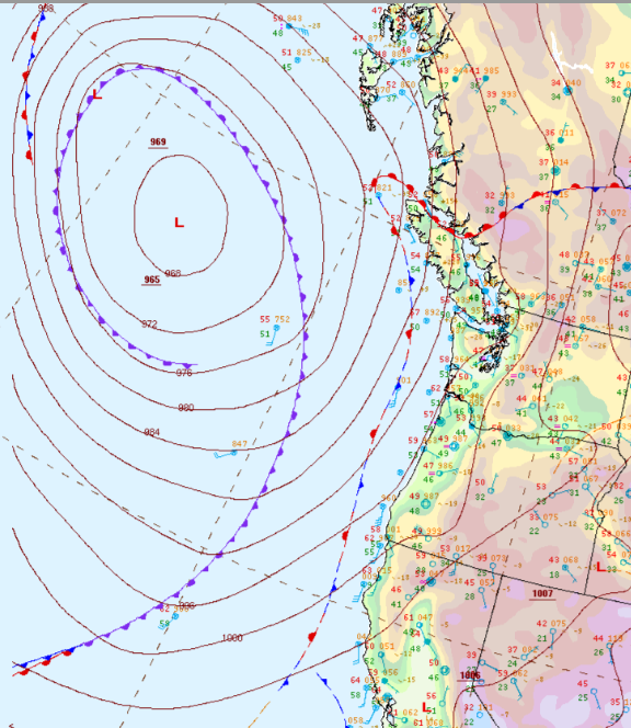
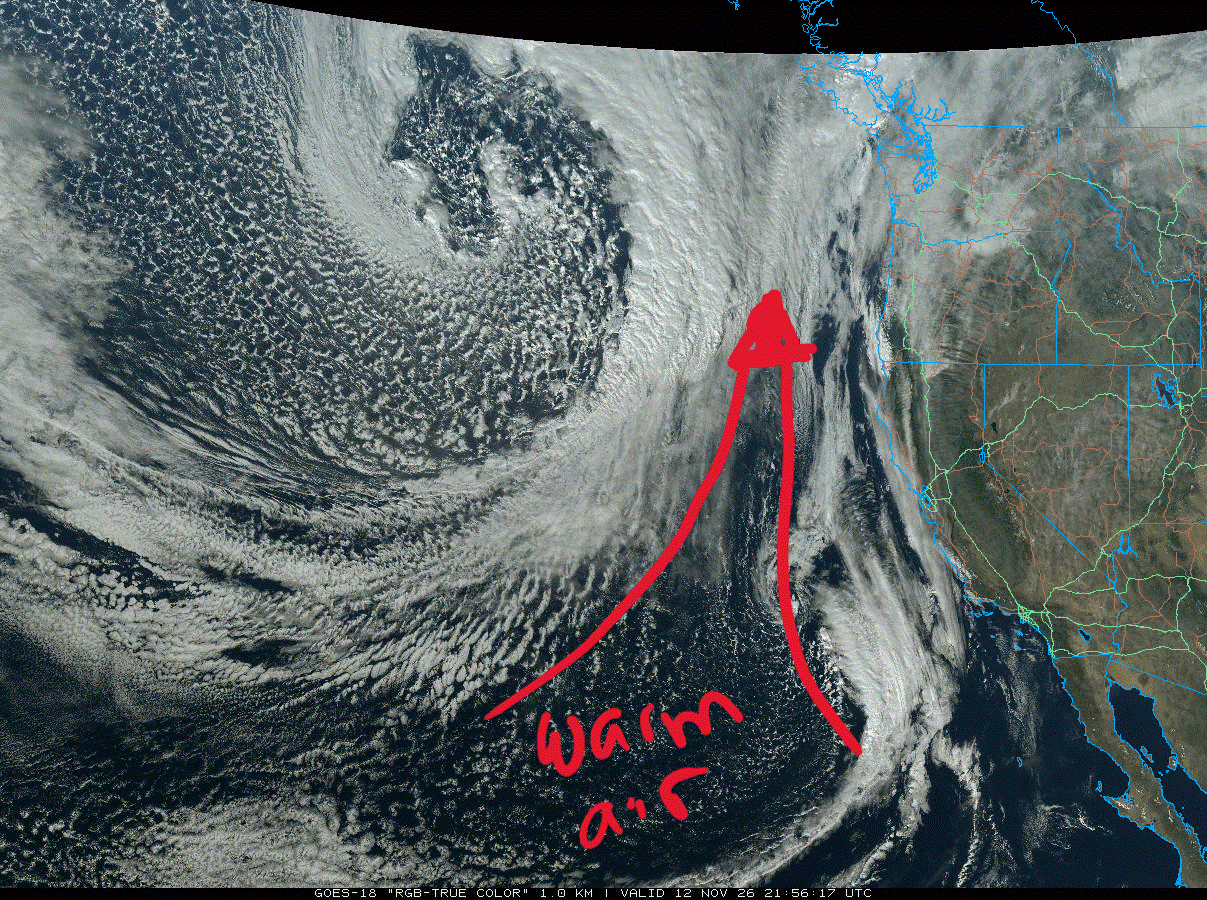
The large-scale atmospheric pattern for this weekend is characterized by continued Gulf of Alaska troughing, which will stay in place for the next several days. This setup is supported by a very strong jet stream over the North Pacific, which helps direct storms into our region. This pattern will support the continued assault of frontal systems impacting our area, though each one carries a different flavor. A front has been stalled along the coast, ushering in very mild air from the south, but it finally moves east on Friday, dropping temperatures and bringing precipitation to many mountain locations. Once that system passes, we prepare for the next one to arrive Saturday night accompanied by strong winds, precipitation, and dropping freezing levels.
- Pattern: Continued Gulf of Alaska troughing with a strong jet stream aloft over the North Pacific.
- Key features this weekend: Warm system (followed by cool air) moves through Friday before a stronger, windy system Saturday night into Sunday.
- Model agreement: Good model agreement on the general precipitation patterns and timing.
🧰 Related tools: Upper Air and Surface WeatherSatellite loopSkew-T / soundings
3. Local Overview
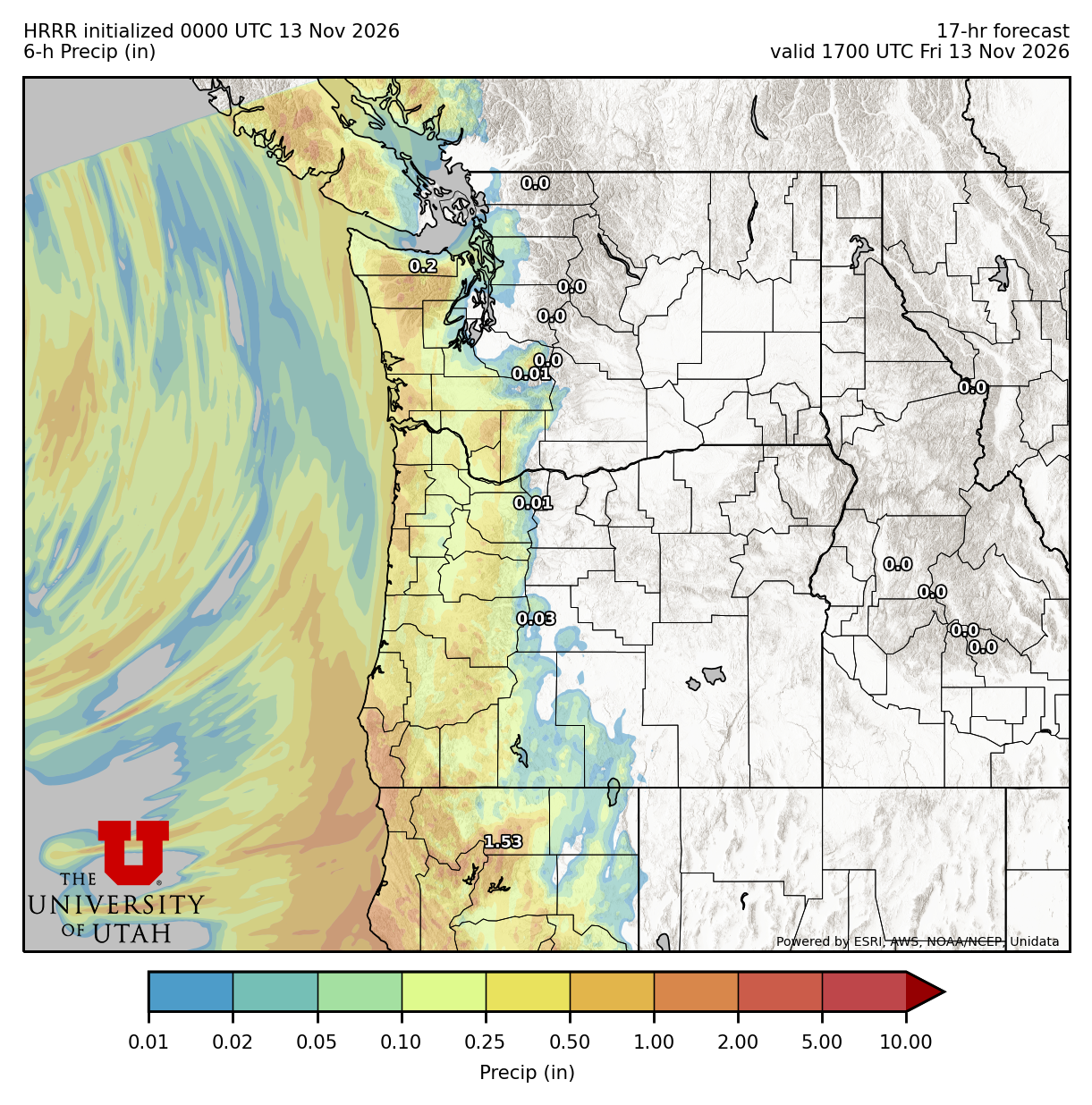
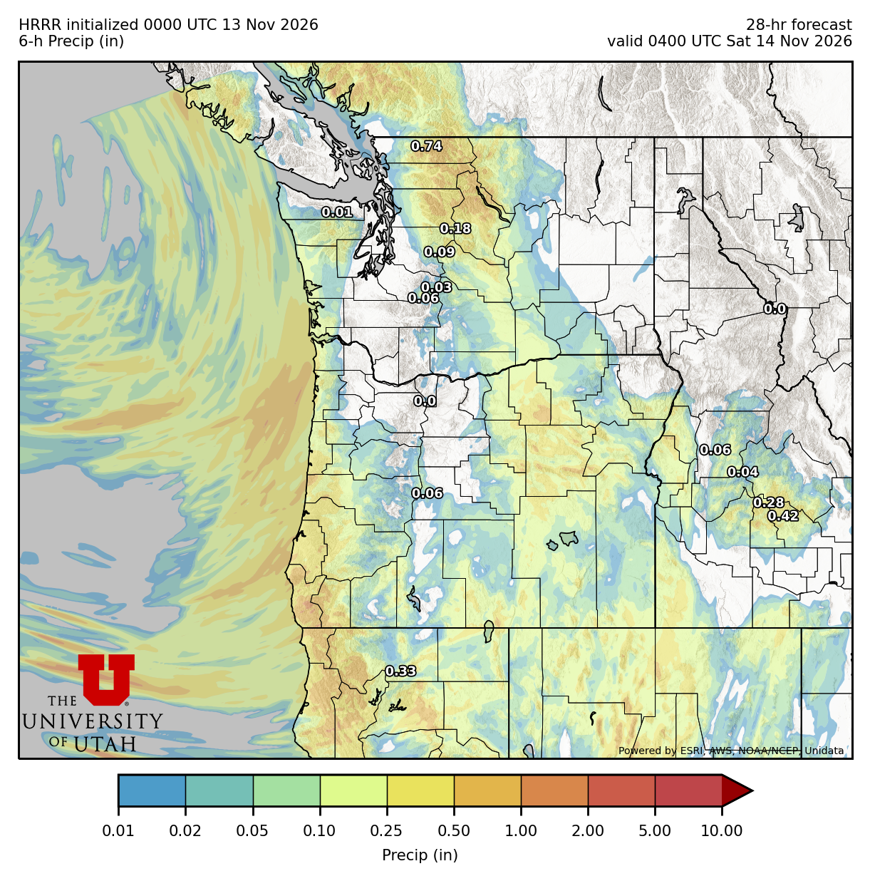
Precipitation during Friday's system will accumulate from the southwest to the northeast, and temperatures will drop significantly. The western Olympics will see the most precipitation no matter what. Saturday will likely see scattered showers, with occasional sun breaks more likely in the central and southern Cascades. Cold air will arrive with the cold front Saturday night. Precipitation will be concentrated with that frontal passage, but scattered showers will continue Sunday.
- Friday: Warm frontal passage in the morning with temperatures decreasing throughout the day. Rain is expected at most mid-elevation mountain locations as freezing levels drop towards 5-6k feet.
- Saturday: Scattered showers, sun breaks for the central and southern Cascades.
- Sunday: Late Saturday and early Sunday frontal passage with highest precipitation rates overnight.
Snow level & temperatures
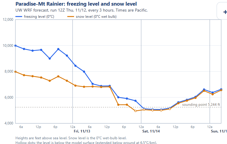
Freezing levels will descend from their lofty heights (around 9-10k feet) on Friday, bottoming out around 5-6k feet on Saturday. Freezing levels will rise into the evening Saturday as the next frontal system approaches, but will drop again towards 4000 feet on Sunday. This cooler air will persist into next week.
Winds
High winds will be most visible along the coast, but the mountains are also expected to see strong winds, especially during the frontal passages Friday afternoon and Saturday night. Both the RRFS and HRRR models indicate sustained winds in excess of 20-30 mph for these events, with stronger gusts likely.
🧰 Related tools: PrecipitationFreezing & snow levelLowland snowSkew-T / soundings
4. Snow Forecast: Map, Plumes and Table
Click a location on the map (or its name below it) to see that site's snowfall and liquid precipitation plumes and its snow table. Sites are colored by their weekend total.
🧰 Related tools: Precipitation toolsFreezing & snow levelSki model meteograms
5. Weekend Winners (and Losers)
🏆 Winners
- Central Cascades Saturday: similar to last week, this is the window to get out for some less wet outdoor fun!
- Mt. Baker Sunday: If you need to see some flakes flying and get a quick snow fix, drive up to Baker Sunday. It won't be skiable, but can scratch the winter itch.
🥀 Losers
- Early season snowpack: This last week's continued warm and wet conditions nuked whatever mid-elevation snowpack we had built. It's as if Sisyphus amuses himself by making us restart our snowpack over and over.
Best bet this weekend: As mentioned above, the Central Cascades Saturday is your best bet to enjoy what will likely be some of the last fall colors.
🧰 Related tools: Powder Stash PredictorPrecipitation tools
6. Mid-Range (Early Next Week)
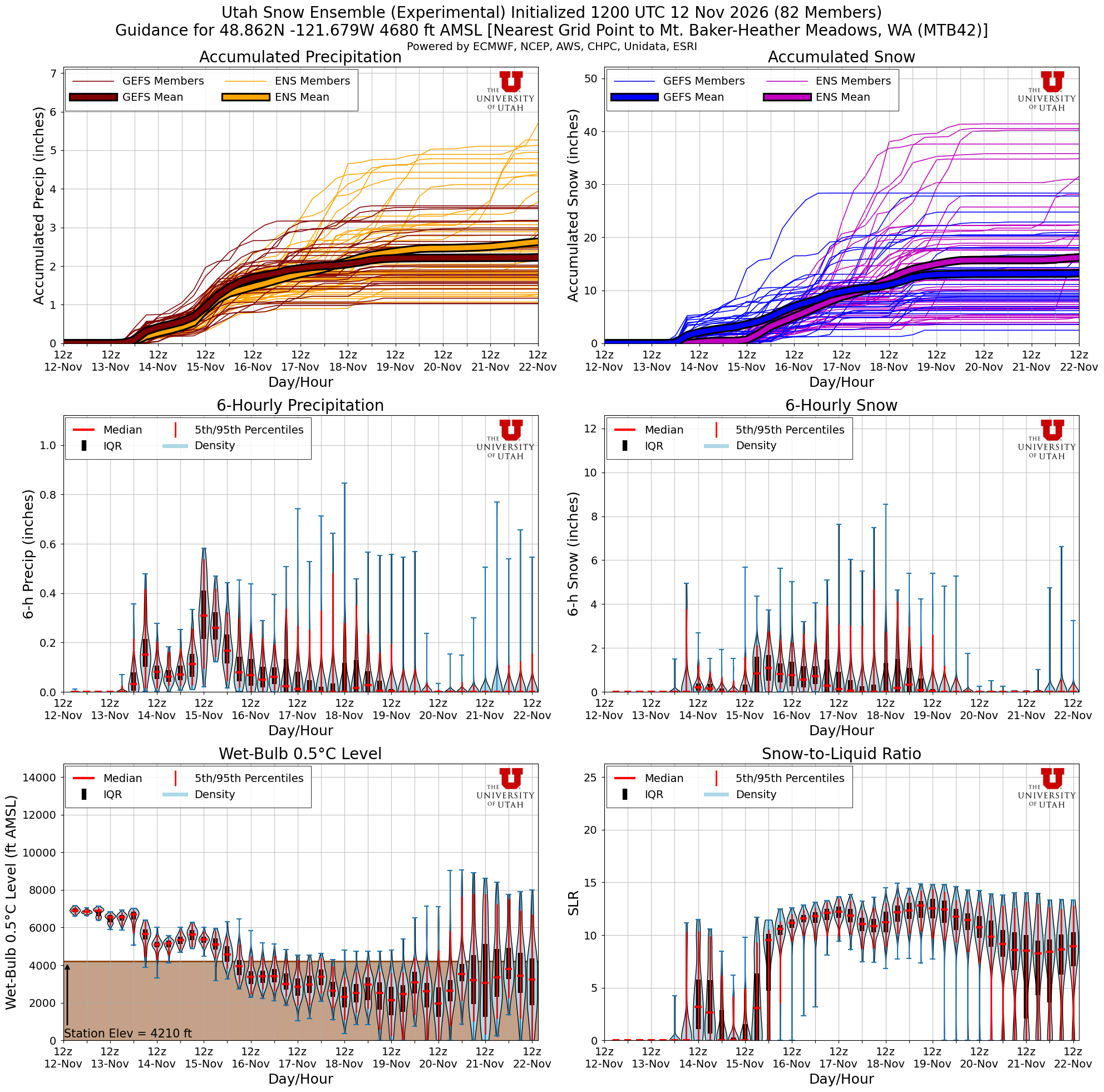
Several more rounds of precipitation should arrive over the early part of next week, with chances for snow accumulations above 4500 feet. The exact amount and timing of the precipitation are still uncertain. A closed low looks to approach the CA/OR border that will keep us clear of precipitation for the latter part of next week.
Confidence: somewhat low. In this mid-range, snow or precipitation totals are difficult to call as there is a lot of uncertainty in how much left over moisture there will be to keep rain/snow falling.
🧰 Related tools: Upper Air and Surface WeatherPrecipitation toolsFreezing & snow level
7. Long-Term Outlook
- Weeks 2–3: Both the ECMWF and CPC agree temperatures will be near-normal to above average and precipitation will be near-normal or below average. Not the best set up for building our snowpack.
- Signals to watch: Continued Pacific Trough conditions, which are a normal signature of El Niño and often bring normal to wet and warm conditions to us.
- Season context: It's still early, but snow and precipitation are sitting below normal for mid-November throughout the Cascades. We'll see if this next week can start to bring us towards normal, though precipitation totals aren't all that impressive.
This is low-confidence territory. Treat it as a hint about the pattern, not a forecast of any single storm.
🧰 Related tools: Sub-seasonalSeasonalTeleconnectionsTea Leaves